The functionality on this page was blocked because content blocking is enabled.
Please use another browser to access the form. We recommend Google Chrome. [Learn More]
Case Study
Ian Walsh, David Murphy, Geoff MacIntyre
April 2018
If billions of phytoplankton fall in the ocean and no one observes it, does it still result in a net sequestration of carbon? In the case of a dramatic deepwater formation event off the Gulf of Lyon in the winter of 2013, the ‘fall’ was seen by an autonomous float equipped with the biogeochemical sensors needed to record the event.
Profiling floats have proven to be a stalwart technology economically generating robust basin scale data sets of temperature and salinity (http://www.argo.net) that have significantly increased our fundamental understanding of the ocean (http://www-argo.ucsd.edu/Bibliography.html). The Navis BGC floats take advantage of advances in float technology and sensor miniaturization (Barnard and Mitchell, 2013) to expand the capability of the float technology to carry a broad suite of biogeochemcal sensors. With sensors for dissolved oxygen, phytoplankton pigments (chlorophyll), particle mass concentration and particulate organic carbon (backscattering and beam attenuation), dissolved organic matter (fDOM), nitrate and pH, the Navis float platform can be used to autonomously monitor the major parameters of biogeochemical processes.
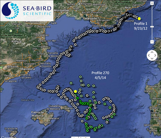
In September of 2012, Sea-Bird Scientific’s Navis BGC s/n 0028 profiling float equipped with a SBE 41 CTD, SBE 63 ODO, and WET Labs ECO Triplet with chlorophyll and CDOM fluorometers as well as a 700 nm backscattering sensor was released at the BOUSSOLE site southeast of Nice, France. The float proceeded to collect 270 profiles through April of 2014. The float incorporated Iridium two-way satellite communications for fast data transfer and mission adaptation. The float deployment was generously supported through the efforts of Dr. David Antoine with assistance from Emilie Diamond during the cruise. Data management on shore was managed through the assistance of Dr. Hervé Claustre and Antoine Poteau. Additional feedback from Dr. Fabrizio D’Ortenzio and Dr. Lois Prieur regarding profile questions specific to the Mediterranean basin was greatly appreciated. All individuals are associated with the Marine Optics and Remote Sensing Lab at Laboratoire d’Océanographie de Villefranche (LOV). The BOUSSOLE program is described in detail at the website: obs-vlfr.fr/Boussole/html/home/home.php.
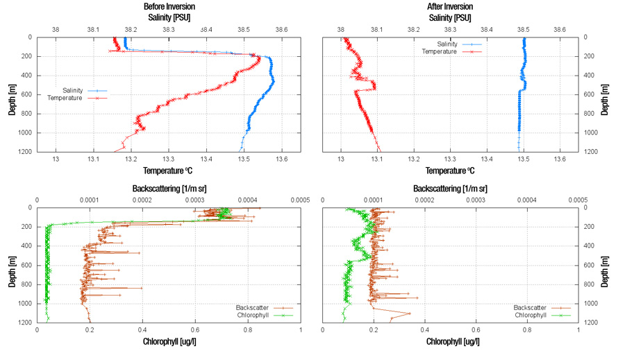
Between February 10th and the 23rd (profiles 93 and 97 respectively), the typical oceanic structure of a mixed layer and pycnocline above the low chlorophyll mesopelagic zone completely collapsed. The deep water mixing event produced a signature water column structure (or lack thereof) with temperature increasing with depth due to adiabatic heating and salinity relatively uniform throughout the upper 800 m (Figure 2).
Figure 2. Profiles of temperature, salinity, chlorophyll fluorescence, and backscattering measured by Navis float 028 from two profiles in February 2013 demonstrate the dramatic and rapid extent of the vertical mixing due to the convective overturn event.
The post-overturn chlorophyll concentration profile decreased by a factor of seven in the upper hundred meters compared to the pre-overturn profile while increasing at all depths below the previous location of the pycnocline. Previous work with moored instruments on the slope off the Gulf of Lyon has established that open ocean overturn events off the Gulf of Lyon are pathways for significant fluxes of particulate organic carbon (Stabhalz et al., 2013) that result in increase biological activity in the midwater column (Tamburini et al., 2013). The biogeochemical float profiles collected in this study demonstrate that this flux can occur rapidly, with net vertical displacements of hundreds of meters per day. This mode of rapid vertical transport is significantly faster than average settling velocities derived from particle traps studies (Walsh et al., 1988). This suggests that the biological material reaching depths during an overturn will be less degraded than the ‘normal’ oceanic particle flux which is dominated by aggregates (Walsh, 1992). Reinforcing this is the fact that the biogeochemical float recorded increases at depth in chlorophyll fluorescence, which is generally associated only with viable or recently senescent cells.
Along Slope Sections of Physical and Biogeochemical Parameters
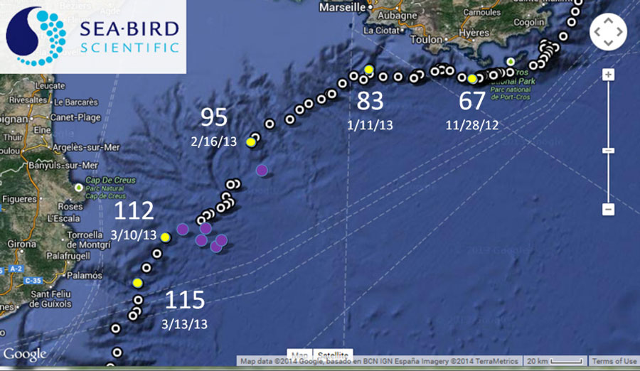
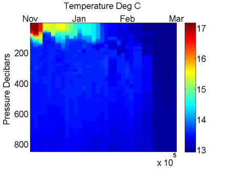
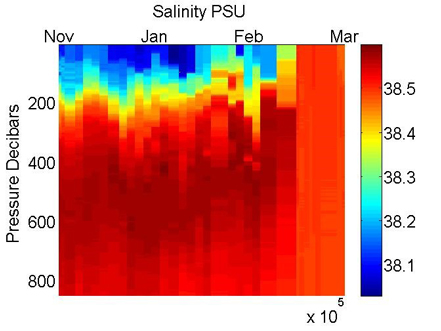
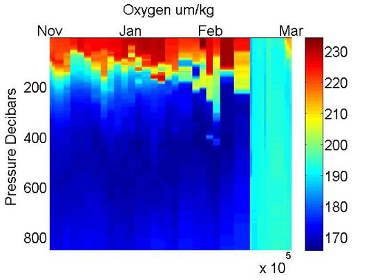
The extent of the overturn in space and time along the Gulf of Lyon is on the order of a month over at least 100 km (Figure 3), with the reemergence of near surface net primary production as indicated by an increase in the dissolved oxygen concentration after about 20 days (Figure 4). Note that the biological response precedes significant stratification in the physical parameters.
Figure 3: The track of Navis BGC float 0028 along the continental slope south of the Gulf of Lyon. Profiles not included in the analysis presented here are indicated by the purple dots. Profiles are highlighted with yellow dots to give a sense of the transit time and to relate position to time in the other figures presented here.
Figure 4. Cross sections of physical and biogeochemical parameters on profiles by Navis BGC float 0028 as it traversed the continental slope off the Gulf in Lyon. Profile data has not been smoothed. Note the deep mixing event in late February that continues into March.
Net flux of Chlorophyll
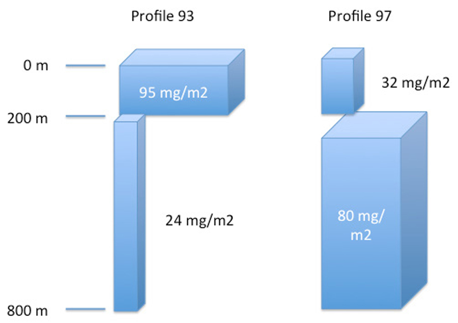
Integrating the chlorophyll concentrations in the nominal photic zone (0 – 200 m) through the upper mesopelagic (200 – 600 m) demonstrates that more than 50 mg Chl/m2 was removed from the photic zone and injected into the upper mesopelagic. If we assume the area of the overturn was 100 km2 (e.g. Figure 4 in Stabhalz et al., 2013), then the net chlorophyll flux to the mesopelagic is on the order of half a million kg of chlorophyll (Figure 5).
Figure 5. Integrated chlorophyll loads in the photic zone (0 to 200 meters) of the water column compared to the upper mesopelagic zone (200 to 800 m) for the two profiles shown in Figure 2.
As biogeochemical float capabilities have increased and early adopters have reported results (e.g. Boss et al., 2008), the oceanographic community has proposed wide utilization of the technology (Johnson et al., 2009, Claustre et al., 2010). One challenge for global processes studies of biogeochemistry with profile floats is that the floats are designed for open oceans, while the many significant biogeochemical gradients are along the margins. Therefore, to adequately address biogeochemical processes and fluxes, greater data density is required along the margins relative to basins. Two-way communications and adjustable sampling regimes have helped increase the utility of biogeochemical profiling floats. Recently, profiling floats have been successfully used to study physical processes driving shelf/slope interactions (Mihanovic, H et al., 2013) and biogeochemical dynamics across the slope to the basin (Green et al., 2014).
Summary
A Navis BGCi profiling float deployed in the north western Mediterranean in 2012 collected data on the basin slope as it travelled west and captured a rapidly developing overturn event. The biogeochemical sensors on the profiling float allowed for the calculation of net transport of particulate material associated with the overturn. This suggests that profiling floats can be used to generate data sets to monitor slope to basin biogeochemical fluxes and processes at densities that can reliably capture the most significant events
Barnard, A. & Mitchell T., 2013. Biogeochemical Monitoring of the Oceans using autonomous profiling floats. Ocean News and Technology, V19 (2) p 16-17.
Claustre, H. et al., 2009. Bio-Optical Profiling Floats As New Observational Tools For Biogeochemical And Ecosystem Studies: Potential Synergies With Ocean Color Remote Sensing. DOI: 10.5270/OceanObs09.cwp.17.
Green, R. et al., 2014. First Autonomous Bio-Optical Profiling Float in the Gulf of Mexico Reveals Dynamic Biogeochemistry in Deep Waters. DOI: 10.1371/journal.pone.0101658.
Johnson, K. et al., 2009. Observing Biogeochemical Cycles at Global Scales with Profiling Floats and Gliders. Oceanography Vol. 22, No. 3.
Mihanovic, H et al., 2013. Exceptional dense water formation on the Adriatic shelf in the winter of 2012. DOI:10.5194/os-9-561-2013.
Boss, E. et al., 2008. Observations of pigment and particle distributions in the Western North Atlantic from an autonomous float and ocean color satellite. Limnol. Oceanogr., 53(5, part 2), 2008, 2112–2122. DOI: 10.4319/lo.2008.53.5_part_2.2112.
Tamburini C. et al. 2013. Deep-Sea Bioluminescence Blooms after Dense Water Formation at the Ocean Surface. DOI: 10.1371/journal.pone.0067523
Stabholz, M.,et al., 2013. Impact of open-ocean convection on particle fluxes and sediment dynamics in the deep margin of the Gulf of Lions. DOI:10.5194/bg-10-1097-2013.
Walsh I., J. Dymond and R. Collier, Rates of recycling of biogenic components of fast settling particles derived from sediment trap experiments, Deep-Sea Res., (35):43–58, 1988.
Walsh, I. 1992. Large Aggregate Flux and Fate at the Seafloor: Diagenesis During the Rebound Process. In: Deep-Sea Food Chains and the Global Carbon Cycle, G.T. Rowe and V. Pariente, eds. pp. 365–373, Kluwer Academic 1992.